

Amphibious Assault Direction System AN/KSQ-1
 Naval Expeditionary Forces currently have the ability to generate and exploit the air and surface picture in carrying out required
Amphibious missions. Sources generate location of Landing/ground forces are limited and not sufficient to generate a timely,
accurate picture. The ability to provide a complete, coherent and accurate tactical picture, both vertically up the chain and
horizontally to supporting forces is needed. Critical to this sensor is the ability to command/control forces BLOS and execute fire
support while preventing fratricide. Current systems, such as KSQ-1 and PLRS are unfunded, unsupported and not under
further development. These systems are urgently required to support ship to shore movement (LCAC�s) or need to be absorbed
into a higher level system.
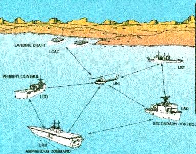
The Amphibious Assault Direction System
(AADS) AN/KSQ-1 command and control data system that
provides real-time information to the Amphibious Command Ship
(ACS), Primary Control Ship (PCS), and the Secondary Control Ship
(SCS) on the position and movement of Naval surface landing craft
in the Amphibious Task Force (ATF). The AN/KSQ-1 will allow
ACS/PCS/SCSs to identify, track, communicate with, and control
amphibious landing craft from launch through transit
Over-The-Horizon (OTH), off-coast, and return while conducting
maneuver warfare from the sea. The AADS will provide positional
information on all amphibious Participating Units (PUs), means to
disseminate navigational information, means to utilize existing
secure voice radio relay system(s) that extend surface-to-shore
control nets beyond the line of sight, digital communications
link for exchanging preformatted messages among PUs, and
interoperability with Position Location Reporting Systems
(PLRSs). The AADS provides cryptographic security and anti-jam
capability.
AN/KSQ-1 combines PLRS and data from the Global Positioning
System (GPS) and other existing ship and landing craft equipment
with desktop computers (workstations) and software to provide the
capability to direct amphibious warfare from the sea. An OTH
capability is achieved by use of airborne relay equipment for
communications among units of the ATF.
The Amphibious Assault Direction System AN/KSQ-1 over-the-horizon (OTH), amphibious assault, command and control system provides the capability to identify, track, communicate with, and control landing craft from launch through transit, offload and return. Beyond line-of-sight communications during an amphibious operation is achieved through the use of an airborne relay. The AN/KSQ-1 combines data received from the U.S. Marine Corps Position Location Reporting System (PLRS) with data from the Global Positioning System (GPS) and existing ship and landing craft equipment, using TAC-() ruggedized, rack mounted workstation computers to provide the capability for command and control of surface ships and landing craft in an OTH amphibious assault at ranges up to 100 nautical miles.
The combining of PLRS with GPS position data creates a dynamic reference unit which allows the AN/KSQ-1 to provide accurate position data without the need for fixed reference stations. PLRS provides position location information to the AN/KSQ-1 workstation where all AN/KSQ-1 equipped platforms within the Amphibious Operational Area (AOA) can be displayed. PLRS also provides the jam-resistant and low probability of intercept communications links for the exchange of pre-formatted and free text messages among members of the Amphibious Task Force (ATF).
The AN/KSQ-1 is comprised of four equipment groups: Amphibious Command Group (ACG, designated as the OA-9436(V)/KSQ-1(V)) installed on LHD/LHS class ships serving as Amphibious Command Ships; Primary/Secondary Control Group (PCG/SCG, designated as the OK-621(V)/KSQ-1(V)), installed on amphibious ships serving as Primary/Secondary Control Ships; User Terminal Group (UTG, designated as the OW-114(V)/KSQ-1(V)) installed on Landing Craft, Air Cushion (LACAL) and some amphibious ships; and Radio Relay Group (RG, designated as the OZ-70)/KSQ-1(V)) designed for rotary wing aircraft.
The ACG provides Commander, Amphibious Task Force (CATF) with a graphic display to monitor the amphibious assault and communicate with the ATF units in a cryptographically secure environment from OTH. It contains the shipboard components of the PLRS Master Station, the AADS workstation, the PLRS Basic User Unit (BUU) and the Global Positioning System Interface Unit (GPSIU); however, PLRS is defined separately within the Amphibious Assault Command and Control System section. The PLRS Master Station controls the PLRS network, performs all calculations, routes all messages, and queries and graphically displays the positions of active PLRS BUUs.
The PCG and the SCG are identical equipment suites on separate control ships. They contain the same equipment as the ACG, except for the PLRS Master Station. Prior to landing force deployment, the approved assault plan control data (departure points, control points, penetration points, landing zones, transit lane dimensions, etc.) will be entered into the PCG workstation and copied to the ACG and SCG workstations. The PCG maintains the master data base for the amphibious assault. The BUUs in the ACG/SCG are party-line capable, that is, they can listen in on the PLRS RF messages sent to the PCG, thus maintaining a duplicate data base. This capability will be greatly enhanced when the United States Marine Corps (USMC) PCE upgrade is fielded in BUUs. The SCG can assume the duties of the PCG when directed or in case of PCG failure.
The UTG is available in two configurations, depending on whether it will be installed on LCAC or on a ship. It's primary components are the GPSIU, BUU and associated ancillary equipment. automatically provides position information to the command and control groups.
The RG is a temporary mission package that contains two BUUs and ancillary equipment. The mission package is stored on the shipboard platform and installed on an airborne platform during amphibious operations.
Sources and Resources
http://www.fas.org/man/dod-101/sys/ship/weaps/ksq-1.htm
Maintained by Robert Sherman
Originally created by John Pike
Updated Wednesday, June 30, 1999 4:31:35 AM
 Naval Expeditionary Forces currently have the ability to generate and exploit the air and surface picture in carrying out required
Amphibious missions. Sources generate location of Landing/ground forces are limited and not sufficient to generate a timely,
accurate picture. The ability to provide a complete, coherent and accurate tactical picture, both vertically up the chain and
horizontally to supporting forces is needed. Critical to this sensor is the ability to command/control forces BLOS and execute fire
support while preventing fratricide. Current systems, such as KSQ-1 and PLRS are unfunded, unsupported and not under
further development. These systems are urgently required to support ship to shore movement (LCAC�s) or need to be absorbed
into a higher level system.


