


Norfolk Naval Station
The Norfolk area, the largest concentration of naval activity on the east coast of the United States, is situated in the southeast corner of the
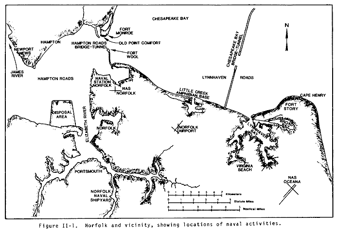
State of Virginia at the southern end of Chesapeake Bay. Norfolk Naval Station lies at the eastern shore of Hampton Roads. Hampton Roads is a natural tidal basin formed by the confluence of the James and Elizabeth Rivers. The entrance to Hampton Roads for all deep draft ships lies between Old Point Comfort and Fort Wool. Not only is Hampton Roads the gateway to the Naval Station, but also provides access to commercial and naval activities at Norfolk and Portsmouth on the Elizabeth River, extensive shipbuilding and cargo handling facilities at Newport News, and many smaller facilities and marinas along the James and Elizabeth
Rivers. Therefore, the whole area is extremely busy with marine traffic.
The Norfolk area has a large number of berths, anchorages, facilities and services available.
The Hampton Roads area comprises the cities of Norfolk, Chesapeake, Suffolk, Virginia Beach, Portsmouth, Newport News, Hampton, and Yorktown. There are a number of Naval commands in the
area, including the Naval Station Norfolk; Norfolk Naval Shipyard, Portsmouth; Fleet Combat Training Center Atlantic, Dam Neck; Naval Amphibious Base, Little Creek; and Naval Weapons Station, Yorktown; Naval Air Station, Norfolk; Naval Air Station, Oceana. Located at these installations are hundreds of commands, large and small, afloat and shore.
Norfolk, Virginia, is located at the southeastern part of the state and at the southwestern corner of the Chesapeake Bay. The US Naval Station piers at Norfolk are located about 18 nmi west of the entrance to the Chesapeake Bay from the Atlantic Ocean. To reach the piers, vessels from the ocean must transit Thimble Shoal Channel, which crosses the southern end of the Chesapeake Bay; pass through the bridge opening at the lower end of the Chesapeake Bay Bridge-Tunnel; pass between Old Point Comfort on the north and Fort Wool on the south; transit the Entrance Reach Channel at Hampton Roads; and enter the Norfolk Harbor Reach Channel which is adjacent to the west side of the Naval Station. The channels are maintained at a minimum depth of 45 feet. Except for areas close to shore, the water is about 18 feet deep from the Atlantic Ocean to Hampton Roads. The channel boundaries are marked by numerous buoys along the route. The buoys are generally 1/4 nmi apart near turns to about 1 nmi apart along straight sections of a channel.
In 1969 and 1970 US Army Corps of Engineers' (COE) dredging of the channels to a depth of 45 feet was completed in the Hampton Roads area and the Thimble Shoal Channel. The depths and channel configurations were maintained accordingly until the COE was authorized under a project entitled "Norfolk Harbor and Channels, Virginia" to dredge channels in the Hampton Roads area and Thimble Shoal Channel to a depth of 55 feet, in two phases. During phase I, which was completed December 15, 1988, the COE dredged 650 feet of the outbound-side of the 1,000-foot wide channels at Thimble Shoal, Entrance Reach, Newport News, and Norfolk Harbor Reach to a depth of 50 feet and the remaining 350 feet on the inbound-side were maintained at 45 feet. The Entrance Reach Channel was also reduced in width from 1,500 feet to 1,000 feet. The COE commenced phase II, dredging the 650-foot channel width to the 55-foot depth and the 350-foot side to the 50-foot depth, in fiscal year 1991.
The Hampton Roads area is been divided into five sub-areas:
NORFOLK
- NAVSTA Norfolk
- NAS Norfolk
- CINCLANTFLT Compound
- Craney Island
- St. Juliens Creek Annex
- Deperming Crib
- Golf Anchorages
LITTLE CREEK
- NAVPHIBASE Little Creek
- NAS Oceana
- FCTC LANT Dam Neck
- Fentress Field
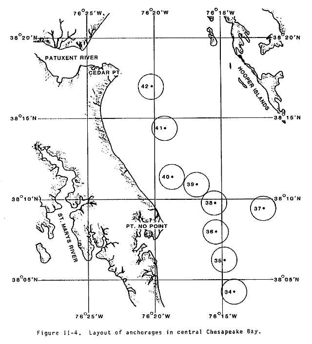
- Lynnhaven anchorages
- NAVMASSO
- NAVSECGRUACT Northwest
PORTSMOUTH
- NAVSHIPYD Norfolk
- NAVHOSP Portsmouth
- RADTRANSFAC Driver Norfolk
- Shipyards at Brambleton, Berkley and Metro
- ANA Shipyard
- Moon Engineering
- Jonathan Corporation
- St. Helena's
NEWPORT NEWS
- SUPSHIP Newport News
- MARCORESCEN Newport News
YORKTOWN
- WPNSTA Yorktown
- Cheatham Annex
- York River anchorages
These installations serve as homeports for approximately 127 ships and 29 aircraft squadrons. Together they comprise the Navy in Hampton Roads. Normally a "visit ship" is open to the general public for touring. However, due to recent international developments, security has been heightened around all US Military bases and all scheduling for "visit ships" has been suspended indefinitely.
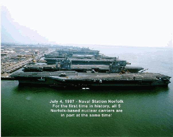
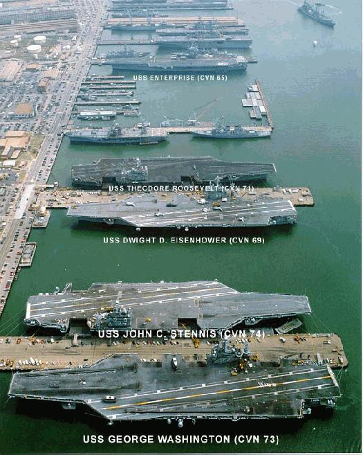
Naval Station Norfolk is homeport for more ships than any other and is the world's largest naval base. When the approximately 90 ships homeported here are not at sea, they are alongside one of the 15 piers for repair, refit, training and to provide the ship's crew an opportunity to be with their families. Naval Station is homeport to aircraft carriers, cruisers, destroyers, large amphibious ships, submarines and a variety of supply and logistics ships. It is uncommon for these ships to all be in port at one time. Naval Station Norfolk made history with the berthing of five (5) Nuclear Aircraft Carriers on 02 July 97 at 1730, when the Navy's newest Nimitz class carrier, USS JOHN C. STENNIS (CVN-74), returned to port, joining the USS GEORGE WASHINGTON (CVN-73), USS THEODORE ROOSEVELT (CVN-71), USS ENTERPRISE (CVN-65) and the USS DWIGHT D. EISENHOWER (CVN-69).
The only other time five carriers were berthed at the Naval Station was in 1992, but they were not all nuclear carriers.
Port Services controls more than 3,100 ships' movements annually as they arrive and depart their berths. Port facilities extend more than four miles and include some seven miles of berthing space. Naval Station's Nimitz Hall is a major stopping-off point for people destined for ships and stations overseas. Nearly 30,000 people are processed through the Transient Personnel Unit annually en route to their destinations.
The Magnetic Silencing Facility maintains and operates degaussing ranges at the Sewells Point Degaussing Range and Lamberts Point Deperming Station and magnetic treatment and calibration services at Lamberts
Point Deperming Station. The Station provides degaussing services, including ranging and deperming for US Navy, US Government and friendly nation ships. They also provide technical reports as required, maintain degaussing records of all US Navy ships, and provide on board
technical and administrative training to both US Navy ships and friendly nation Navies.


Sources and Methods
http://www.fas.org/man/dod-101/fac/port/norfolk.htm
Maintained by Robert Sherman
Originally created by John Pike
Updated Tuesday, December 15, 1998 9:56:06 AM


